Celestial Air Navigation Text, Office of the Chief of the Air Corps,
1937, Randolph Field Printing Office - March 1, 1937 - 3500
CELESTIAL AIR NAVIGAT10N TEXT
Prepared under the direction of the Chief of the Air Corps
1937
TABLE OF CONTENTS
Chapter Page
I. Definitions and the fundamentals of celestial navigation . . . . . . . .
. . .1
II. Position circles. The astronomical triangle and its reduction . . . . .
. .11
III. Time and the nautical almanac . . . . . . . . . . . . . . . . . . . .
. . . . . . . .21
IV. The sextant and the errors of observation . . . . . . . . . . . . . . .
. . . . 41
V. Position lines and their use . . . . . . . . . . . . . . . . . . . . . .
. . . . . . . . . 53
VI. Precomputed curves; simultaneous star altitude curves;
change in
altitude tables; other reductions. . . . . . . . . . . . . . . . . . . . .
. 59
VII. Star identification and the Rude Star Finder . . . . . . . . . . . . .
. . . . 71
VIII. Latitude and azimuth by Polaris; compass swinging by celestial
azimuths . . . . . . . . . . . . . . . . . . . . . . . . . . . . . . . . .
. . . . . . . . . . . . . 79
IX. Flight Preparation . . . . . . . . . . . . . . . . . . . . . . . . . .
. . . . . . . . . . . 83
FOREWORD
The following celestial navigation text is patterned after the course in
this subject given by the 19th Bombardment Group.
Since previous extensive training in the astronomy of navigation is seldom
met with, liberties have been taken in the matter of terminology when such
have been thought desirable. It is believed that the subject matter is so
compiled as to eliminate the necessity of the usual index.
At the end of the first few chapters several usual questions are
propounded and answered. Sample observations using sun, moon star and
planet, will be found after the last chapter. Earlier will be found
examples of the problems of computing sidereal time and of obtaining
latitude and azimuth from Polaris. All of these will be found useful
references for the student when difficulties are encountered in such
problems.
The subject of time is most difficult for the beginning student in
navigation. It is presented in an entirely original manner in this text.
Every effort has been made to remove many of the usual obstacles. Let this
not be interpreted to mean that the subject, as here presented, will be
mastered easily. Regardless of the method of presentation, the subject of
time will be found difficult.
Increasing demands for greater accuracy in aircraft sextant observations
will doubtless result in the development of satisfactory averaging devices
for existing bubble and pendulum sextants and the development of
gyroscopic sextants, both of which will yield a sufficiently accurate
single observation. This is the greatest need in celestial air navigation
at present. Several mechanical computers are on the market. It is argued
that these will reduce the number of arithmetical mistakes made in hurried
reductions common to air navigation. Such devices do not eliminate the
necessity of using the almanac. However, the incorporation, in a computer,
of certain almanac data is certainly within the realm of possibility. On
the other hand, years of navigation practice have been responsible for the
development of many excellent tables and booklets that will be difficult
of replacement by mechanical means.
Regardless of the path the navigator chooses to follow in his selection of
equipment, tables, computers, etc., nothing will be found to have the
general utility and the value of a thorough understanding of the
fundamentals of navigational astronomy. Such a knowledge can come only
from study and practice. The purpose of this text is to aid the beginner
in the former.
CHAPTER I
DEFINITIONS AND THE FUNDAMENTALS OF CELESTIAL NAVIGATION.
An understanding of several terms used, frequently in celestial navigation
is necessary before the general principles upon which the art' is based
may be studied. A knowledge of the terms used in D. R. navigation is
assumed, and only those needing special clarification or emphasis will be
touched upon in this chapter. The definitions - and usages of the
necessary D. R. terms are fully covered in Chapters I to IV, Hydrographic
Office Publication #9 (The American Practical Navigator, Bowditch), which
publication should be a part of every navigator's equipment.
THE EARTH. The earth is an oblate spheroid, being a nearly spherical body
slightly flattened at the poles; its equatorial axis measures about 7,927
statute miles and its polar axis, around which it rotates, about 7,900
statute miles. For the purpose of navigation the earth is regarded as a
true sphere equal in area to the area of the surface of the earth. No
material error results from this assumption and the "mean sphere" will be
assumed in all future references to the earth.
NAUTICAL MILE. The nautical mile is one minute of great circle arc on the
earth's surface. It measures 6,080 feet and subtends one minute of angle
at the center of the earth. Since latitude is measured along great circles
on the earth's surface passing through the geographical poles, one minute
of latitude therefore equals one nautical mile. Unless otherwise stated
the term mile hereafter will imply the nautical mile.
CELESTIAL SPHERE. The celestial sphere is an imaginary spherical surface
of infinite radius which has as its center the observer's eye or the
center of the earth, the two being coincident because of the celestial
sphere's magnitude. To an observer on the earth's surface the heavenly
bodies, interspersed in space at various distances from the earth, appear
projected upon the celestial sphere at points where the lines joining them
with the observer's eye intersect the sphere. An observer conceived to be
at the earth's center and looking through its solid. substance not only
would see the heavenly bodies projected onto the celestial sphere but in
addition would see the imaginary points and circles on the earth's surface
(the geographical poles, meridians, equator, and parallels of latitude)
projected onto it. The imaginary terrestrial points and reference circles
thus projected to the celestial sphere constitute the celestial reference
markings. The only purpose the celestial sphere serves is that it enables
a substitution of spherical triangles to be made for solid angles in the
necessary trigonometrical solutions.
HORIZON. The horizon generally used in aerial navigation is determined by
a bubble, ball, or pendulum in the observer's instrument. The horizon
these devices determine is a plane passing through the observer's eye,
perpendicular to the vertical at his position. This horizon will be
assumed in future references unless otherwise qualified. The visible
horizon is that line appearing to an observer at sea to mark the
intersection of earth and sky.
ALTITUDE. Altitude is the least angular elevation of a body above the
horizon at any instant.
ZENITH. The zenith of an observer on the earth's surface is the point of
the celestial sphere vertically overhead.
ZENITH DISTANCE. Zenith distance of a body is its angular distance from
the observer's zenith. It is the complement of the body's altitude.
AZIMUTH. The azimuth of a celestial body is its bearing measured from the
true north or south point. It is measured 180 degrees to the east or west.
GEOGRAPHICAL POSITION OF A BODY. The geographical position of a celestial
body is a point on earth's surface which is exactly under the given
heavenly body at any one instant. An observer at the geographical position
would find the corresponding body exactly at his zenith.
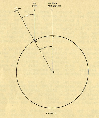 FIGURE I.
Let an observer on the earth be at the geographical position of a heavenly
body, as at A, in Figure 1. At this position the particular body and the
observer's zenith are apparently one. Since the celestial bodies (with one
exception for the present) may be assumed to be at an infinite distance
from an observer on the earth, the particular body being considered will
be seen in the same direction in space when the observer has moved to
position B, 1800 nautical miles from A, measured along a great circle on
the earth. At position A the altitude of the body obviously is 90 degrees
and its zenith distance 0. At position B, though the body appears in the
same direction in space, its altitude and zenith have changed, this being
occasioned by the shift in the positions of the observer's zenith and
horizon resulting from his change of position.
From the definition of 'nautical mile, the Great Circle are joining A and
B subtends an angle of 1800 minutes, or 30 degrees at the earth's center.
The change in the position of the observer's zenith after moving from A to
B obviously is 30 degrees since the radii OA and OB, bounding the 30
degree angle at the earth's center, when prolonged, intersect the
celestial sphere at the zenith of the two positions.
A study of Figure 1 shows that when the observer is at position B the
body's zenith distance is 1800 minutes of angle (or 30 degrees); this
equalling, exactly, the number of nautical miles the observer is removed
from the point vertically beneath that celestial body, that is, from its
geographical position.
An observer situated at the geographical position of a particular heavenly
body could move 1800 miles away from that position along any one of an
infinite number of great circles radiating from that position.
Consequently, there must be an infinite number of points on the earth from
which the body's zenith distance would measure 30 degrees (and its
altitude, 60 degrees) at the same instant. Test would soon indicate that
all these points lay in a small circle of exactly 1800 nautical miles
radius, having the geographical position as its center; and apart from
such tests it is apparent that, if the earth be a sphere, this must be the
case. Such a circle is known as a position circle; an observer being at
all times situated on one of the position circles of every heavenly body
visible from his position.
Altitude and zenith distance are two terms used very frequently in
celestial navigation. It is vitally necessary that their meanings be
clearly committed to memory. Also, they must be associated so completely
that the mention of one term automatically calls the other to mind. It is
the altitude of a heavenly body that is always measured, and not its
zenith distance. Yet it will be seen from later subject matter and
illustrations that it is the zenith distance which is a part of the
astronomical triangle that is solved in each problem. It must be
automatically realized that when the celestial triangle is solved for the
computed zenith distance, the corresponding computed altitude is
available, or that when the altitude is found by measurement with the
sextant the corresponding "measured" zenith distance is available.
Though no visible star exactly marks the position of the north celestial
pole (Polaris is roughly one degree removed), let it be assumed for the
present that one does. An observer who finds the altitude of the star now
marking the exact position of the celestial pole to be 90 degrees would
know himself to be situated at its geographical position, the north
terrestrial pole. The observer's latitude clearly is 90 degrees and the
zenith distance of the celestial pole 0 degrees, thus:
Latitude Zenith Distance Altitude
90. . . . .0. . . . . . . . . . . .90
Now let the observer move 600 miles (nautical) away from the pole along a
great circle. Substituting the terrestrial pole for A in Figure 1 and
redrawing the figure so that the observer's new position is 600 miles or
10 degrees from the pole, it becomes apparent that the following figures
are correct for the coordinates under which they are written:
Latitude Zenith Distance Altitude
80. . . . .10. . . . . . . . . . .80
If the observer moves to the earth's equator in 600 miles, or 10 degree
increments, the following tabulated values are obviously correct for the
three coordinates:
Latitude Zenith Distance Altitude
90. . . . .0. . . . . . . . . . . .90
80. . . . .10. . . . . . . . . . .80
70. . . . .20. . . . . . . . . . .70
60. . . . .30. . . . . . . . . . .60
50. . . . .40. . . . . . . . . . .50
40. . . . .50. . . . . . . . . . .40
30. . . . .60. . . . . . . . . . .30
20. . . . .70. . . . . . . . . . .20
10. . . . .80. . . . . . . . . . .10
0. . . . . .90. . . . . . . . . . .0
If the reader is at all dubious as to the correctness of the above
tabulated figures, he should convince himself of their correctness by
drawing several figures similar to Figure 1, substituting the terrestrial
pole for position A and altering the great circle are AB to correspond to
the observer's distance from the pole. When satisfied with the above
figures, the Zenith Distance column should be covered and the remaining
columns compared comparison of the Latitude and Altitude columns reveals
an astronomical axiom that should be committed lastingly to memory;
namely, that the "Altitude of the Pole equals the Latitude of the
Observer". This axiom is rigorously true as a moment's consideration will
make apparent. Every mile the observer moves away from the pole; that is,
each latitude change of one minute occasions a change of one minute of
angle, or arc, iii- the celestial pole's altitude and zenith distance, the
former decreasing and the latter increasing when the observer moves away
from the pole. If the observer moves toward the pole, the reverse is true.
These facts can be readily seen if Figure 1 is carefully studied. In the
southern hemisphere the rule still holds, the southern celestial pole,
however, being considered instead of the north. The reader should satisfy
himself on this point.
The axiom "The Altitude of Vas Pole equals the Observer's Latitude" was
used unconsciously in sea navigation by many early peoples, - the
Phoenicians, the Chinese, the Pacific Islanders and others, though the
earth was assumed by them to be flat and latitude, as we consider it,
unknown. However, the seafarers of these races were well aware of and
acquainted with the change in the appearance of the heavens with change in
latitude. They were adept at estimating the altitude of celestial bodies,
by eye, to an astonishingly close figure. This ability and aforementioned
knowledge were combined to great advantage by these early seamen. Steering
well to the side of their destinations, these navigators would make good
latitude, north or south, until the pole appeared at the proper altitude,
that of the destination. A course toward the destination which would put,
the pole abeam (an East or West course) would then be steered, since
experience and word of mouth had taught these people that when plying such
a course, the pole's altitude would not change. It was simple necessary to
continue on such a course until the destination was reached.
The Hawaiian Islanders made many remarkable trips to Tahiti and return in
open outrigger canoes (the distance between these ups is approximately
2,300 nautical miles) using their unconscious knowledge of the latitude
axiom as their principle navigation aid. Figure 2 illustrates this.
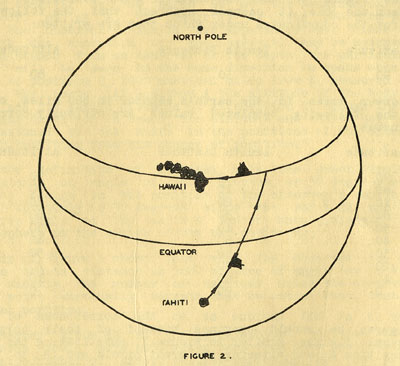
FIGURE 2.
It has been pointed out that a particular is small circle which connects
all points on the earth from which heavenly body is found to have the same
altitude, or the same zenith distance. In the special case in which the
zenith distance is 90 and the altitude 0 degrees the position circle is a
great instead of a small circle. The geographical position of a heavenly
body was said to be the center of any position circle of that body; the
zenith distance being its radius. From the tabulated values used to point
out the latitude axiom, it will be seen that at a latitude of 30 degrees
the pole's altitude is 30 degrees and its zenith distance 60 degrees. It
is apparent that if the altitude of the celestial pole is 30 degrees when
measured from one point on the 30th parallel of latitude it will be 30
degrees when measured from any point on that parallel. Since the 30th
parallel connects all such points, it is clearly one of the position
circles of the north celestial pole. If so, it must have the geographical
position of the sky's pole, the terrestrial pole, as its center. This
obviously is the case. If a position circle, the 30th parallel must have
the zenith distance of the celestial pole as its radius. This, likewise,
is apparent; the 30th parallel being everywhere 60 degrees distant from
the pole. Since the 30th parallel conforms to all requirements; it must be
a full-fledged position circle of the north celestial pole. Every other
parallel of latitude in the northern hemisphere conforms to the same
requirements and is a position circle of the north celestial pole; those
of the southern hemisphere being position circles of the south celestial
pole. The equator alone, of these position circles, is a great circle.
Figure 2 shows, in terms of position circles, the method of navigation
employed not only by the Phoenicians, the Chinese, and Pacific Islanders,
but by many sailing ships of comparatively modern times. The pole was
approached or left until its altitude was found to equal the latitude of
the destination. Thence an East or West course was sailed until the
desired landfall was made. In the sailing ship era instruments were,
employed for altitude measurements and the sun was usually used to
determine, in a method later explained, the ship's latitude. However, the
landfall was frequently made by sailing along that parallel of latitude
passing through the destination.
In the practice of navigation, though little limitation exists in the
matter of selecting bodies to observe, those at about 30 degrees altitude
offer several advantages (to be pointed out later) and are generally
selected for observation when possible. It has been pointed out that the
30th parallel of latitude is the position circle of a point in the sky
(the celestial pole) whose altitude is 30 degrees. Keeping in mind the
fact that position 'circles of this size are most frequently used a large
scale conical map upon which this parallel appears should be consulted.
It should be noticed that the curvature of this parallel, and others near
it, is very slight. Consequently, a moment's consideration makes apparent
the fact that a straight line may be used to represent a portion of the
position circle, a hundred mile length for example, with very little error
resulting from the substitution. A straight line thus used to represent a
small portion of a position circle is known as a "line of position" or
"position line".
A position circle is generally a small circle. However, its radius is
always a portion of a great circle; whose length equals the zenith
distance of the particular heavenly body or point. The position circles of
the celestial poles, the parallel of latitude as has been seen, have as
their radii that portion of the terrestrial meridians included between the
pole and the parallel. An inspection of any globe shows that all meridians
and parallels intersect at right angles and it is quite evident from this
that the radius of any position circle intersects that circle
perpendicularly. Further, it is evident that the radius that contains the
observer's position indicates the direction in which the observed body is
seen from the observer's position. These are not special conditions
applying only to the family of position circles now being considered.
Imagine the meridians and parallels of either hemisphere, northern or
southern, to appear on a tight-fitting transparent hemispherical cap. It
is obvious that the characteristic's of the position circle family are not
changed regardless of how the cap is slid over the surface of the globe.
If the altitude of any visible heavenly body is observed and the
geographical position of that body located on the earth for the instant of
observation, it should be apparent from the foregoing that a position
circle can be drawn on the globe, and that the observer is somewhere on
that circle. The zenith distance of the body, found from its altitude, is
used as a radius and the circle is swung from the geographical position of
the body as a center. Figure 3 shows a position circle drawn on the globe
using the known geographical position of a heavenly body and a zenith
distance found from a measured altitude.
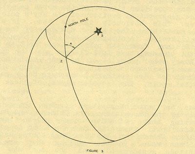
FIGURE 3.
S is the body's geographical position and Z the position of the observer.
Notice the angle A, at the observer's position included between the
observer's meridian and the radius of the position circle. This is the
azimuth of the observed body. The angle at the observer's position
included by the observer's meridian and the radius of the position circle
is, when measured clockwise, the bearing of the body measured from the
north point on the observer's horizon. Thus the angle A conforms to the
definition of azimuth.
It is often thought, and erroneously so, that an observer can obtain his
position on the earth from an observation of one body, providing both the
altitude and azimuth are measured. Theoretically this is possible.

Figure 4 shows a position circle drawn from a measured altitude and
known geographical position. The azimuth angles A and A', at two points on
the circle, are indicated, and it should be carefully
noted that these angles differ in magnitude. From this it maybe seen that
the azimuth angle an observer measures changes as he travels around the
position circle. Consequently, having measured the azimuth, a point on the
position circle could be found at which the radius makes with the meridian
at that point, angle equalling the measured azimuth. The intersection of
the radius and position circle would then mark the observer's position.
Theoretically this is quite correct. It is not practical, however, for the
simple reason that the azimuth cannot be measured to the degree of
accuracy required to permit such a procedure. Since it is quite difficult
for beginning students of navigation to grasp this fact, an explanation of
it will be valuable, and is warranted at this time.
Let the subject of terrestrial bearings in D. R. navigation be considered.
From a theoretical position, A, on a chart or map, as in Figure 5 let the
bearing of a prominent object B be determined. Suppose this bearing to be
60 degrees.
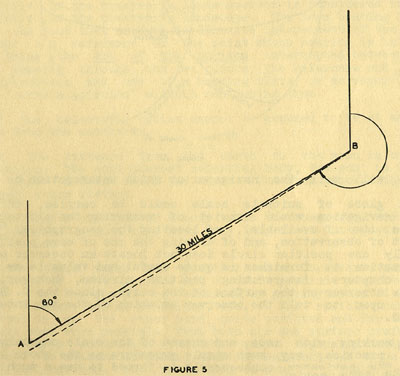
FIGURE 5
If a navigator actually measures the bearing of the point H as 60 degrees
while flying, he is obviously on the line AB, (prolonged if necessary).
This line is plotted on the chart from point B using the reciprocal of the
bearing. Suppose the navigator in flight measures the bearing of point B
as 60 degrees but that his measurement is one degree in error; the actual
bearing of point B from his position being 59 degrees. The navigator plots
line AB and believes himself situated on the line. However, due to the
erroneous bearing measurement, he is actually on the dotted line. If the
navigator's approximate distance from position B is 30 riles, then the
resulting error is 1/2 mile. (1 degree equals 1 mile in 60).
Much the Same situation exists in the case of celestial bearings, or
azimuths, except that the navigators position, instead of being only 30
miles distant from B (the geographical position) is several thousand miles
removed. It is quite evident then that the error in position resulting
from an azimuth one degree in error is of considerable magnitude. Since
even a greater error must be expected in as azimuth measurement made in
flight, an observation of a single body will only tell the navigator that,
he is on a certain position circle. However, if the altitudes of two
heavenly bodies are observed and their corresponding position circles are
drawn, as in Figure 6, the navigator plainly must be at their
intersection. The intersections of any two such circles are so far apart
that the D. R. will tell the navigator at which intersection he is
situated.
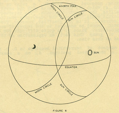
FIGURE 6
If a globe of suitable scale could be carried, the practice of celestial
navigation would consist of measuring the altitudes of one or two bodies
(two if available), of locating the geographical positions for the instant
of observation, and of drawing the one or more position circles. Though
only one position circle does not locate an observer on the earth, the
information it furnishes is quite useful and valuable as will be seen in
later chapters. Intersecting position circles, however, definitely locate
the observer on the surface of the earth, since the D. R. can always be
relied upon to tell the observer at which of the two intersections he is
situated.
When working with maps and charts of the scale commonly employed in
navigation practice, any such simple procedure as the above is out of the
question. The navigator consequently is forced to use a much more devious
process.
QUESTIONS AND ANSWERS
Q... Why is the term "bearing" used in the definition of azimuth?
A... A bearing may be measured with a surveyor's transit or a horizontal
graduated circle upon which two vertical sights are mounted. It is readily
realized that when using these iota the elevation of the reference point,
or the point whose bearing is being taken is of no concern; the magnitude
of the bearing angle being independent of such consideration and only
dependent upon the angle through which the horizontal plate is rotated in
sighting successively on the reference and the point whose bearing is
wanted. Thus, a bearing clearly is an angle measured along the horizontal;
along the observer's horizon, if the bubble or pendulum horizon is
considered rather than the profile of the observer's landscape. The term
bearing is used to impress the fact that azimuth is likewise independent
of the elevation of either the reference or the point whose bearing is
being taken; azimuth being the arc of the horizon intercepted between
vertical circles passing through the two points (the reference and the
body). The construction and use of a bearing plate, or surveyor's transit,
implies "vertical circles" without mentioning them.
Q:.. Which of the celestial bodies cannot be assumed to be at an infinite
distance from the earth?
A... The moon. The distance from the earth to the moon is but 239,000
statute miles. The neat nearest celestial body, the sun, is 93,000,000
statute miles distant from the earth. The star nearest the earth is 4 1/3
light years distant.
Q... Since the zenith distance of a body tells the observer's distance
from the geographical position of that body, why is it not measured
instead
of the altitude?
A... No definite point marks the position of an observer's zenith. The
accelerations of both surface and aircraft preclude positive indications
of the horizontal or vertical by gravity operated mechanisms (liquids,
bubbles, balls, pendulums, etc.). The visible horizon (see definition) is,
on the other hand, quite positive and for this reason is always used when
possible, from both air and surface craft. Therefore, the early instrument
builders quite logically designed their instruments to measure altitude,
since measurement was to be made from the visible horizon. For uniformity
of practice, artificial horizon instruments were built to measure the same
coordinate, though the gravity operated mechanisms of these instruments
indicate the vertical (or the observer's zenith) as well as the
horizontal.
Q... Though the star Polar is does not mark the exact position of the
north celestial pole, can its altitude be used for latitude, as per the
"latitude axiom"?
A... The altitude, of Polaris must be corrected before being taken as the
latitude. The Nautical Almanac provides very simple and handy tables for
this purpose, the use of which will be explained in a later chapter. The
Rude Star Finder, also explained later, provides a quick means of
correcting the altitude of Polaris to permit its use for latitude.
Q... Was the celestial pole depended upon entirely by the early races for
position and direction?
A... No. The am and stars were used for direction and, in many areas; the
constancy of the prevailing, seasonal winds for the same purpose. The
pole, however, was depended upon for position; i.e., latitude.
In the atoll and island areas the natives were able to tell the direction
of land by the visible effect such land had upon the shaping of the ocean
swells. Many travelers of the South Seas have marvelled at the ability of
the natives to unerringly point out the direction of land well beyond the
range of vision after having been several days at sea; these natives
having no knowledge of course or position.
Q... How is the geographical position of a heavenly body located?
A... The location of a geographical position of a heavenly body is a
problem involving time and the Nautical Almanac. These will be studied in
a later chapter.
Q... Is the azimuth of a celestial body ever used?
A... Yes. The equivalent of a measured azimuth is frequently used to check
a craft's compass error. The accuracy needed in such work is not nearly
that which would be necessary to locate the observer's point on his
position circle and, consequently, its use for compass work is permissible
and desirable. Also, the computed azimuth of a body is used to orientate
the position lines of that body; the position lines running at right
angles to the azimuth. The computed azimuth used for this purpose is exact
(mathematically so) because it is calculated for an exact, known location,
which has been arbitrarily chosen. Qbviously, since such an azimuth
presupposes a known location, it cannot be used by the navigator to
establish his location on his position circle. Such an azimuth would only
locate the arbitrary point, if that point were on a known position circle.
Q.. How much error is occasioned in locating a point on a position circle
if the measured azimuth to be used for this purpose is 1 degree in error?
A... While this is dependent upon several variables, an average figure is
plus or minus 50 miles. |